If you’ve read about my second day on the Highline Trail, you may have begun to understand how miserable I was. I had gone to sleep that night, the bugs loud outside my tent, wanting nothing more than to get off the mountain. Well, to my luck, I got some sleep that second night. So things were already better than they had been the first night. I didn’t sleep much, but “not much sleep” is better than “no sleep”. I’m also glad to say that in the morning I was feeling a lot better, and a lot more confident.
As that second night passed, I did wake up around midnight to treat a blister that had formed on my left foot, just behind the big toe. It had already been punctured and drained, so I basically wiped it down with alcohol and put a band-aid on it.
In the morning I had two tasks, purify water, and eat breakfast. Once again, breakfast was Pop Tarts and cereal bars. Which was fine. All my Pop Tarts were crumbed by that point, but that didn’t bother me, so much as the fact that I wanted to eat something that wasn’t so dry. The previous night I had thrown my beef jerky some distance from my tent so that no wild animals would want to get into my tent, and it was there waiting for me, so I had some of that too.
Purifying water was another matter. I really didn’t want warm water again, so my plan was to use iodine tablets. I’ve heard that iodine isn’t the best method for purification, really only for emergencies, but I figured it’d be alright. My water source was a running spring, and it is my understanding that spring water is usually fairly safe to begin with. Additionally, I wasn’t in a popular area for grazing, so I wasn’t worried about germs from livestock.
I also had some pretty bad sunburns on the backs of my arms and legs, from the previous day. My first-aid kit guide said that painkillers would help, and I had some Ibuprofen in the kit, so I popped a pill. That would prove to help quite a bit. I also applied a little bit of sunblock, so that my burns, at least, wouldn’t get any worse.
With breakfast eaten, my water ready, and my bag packed I was ready to start the day. My first destination was Anderson Pass. This would also be, at 12,600 feet, the highest point of my journey. I’d been up Anderson Pass before, on a visit to King’s Peak (the highest point in Utah), but when I’d gone before I’d left my gear at the base, because I was going back the same way. This time I wouldn’t be coming back the same way, so I was carrying all my gear up the pass. That made it a lot more difficult. My progress was slow, and I was expecting to see someone else on the pass, probably passing me by because I was going so slow. I didn’t see anyone going up. I thought I heard some shouting in Painter Basin, behind me, but whenever I looked I didn’t see anyone.
In about two hours from when I started hiking for the day, I made it to the top of the pass. This was around 10:00 AM. I was ready for a break. So I took one. This was also, and you’ll have to forgive my details here, the first time I took a dump on the trip. Yes, indeed, those first two days I didn’t do a number two at all. But there, on top of Anderson Pass, I made a bowel movement, and let me tell you, it was definitely two day’s worth. Don’t worry, I did it out of sight, and while technically it wasn’t buried, as there is really nothing but rocks up there, I mad sure it was covered up.
It got cool, taking a break on the pass. I put my jacket on. My plan was to rest for a whole hour, but after twenty minutes I realized I didn’t need a full hour. Half an hour would be enough. It’s traditional for travelers atop Anderson Pass to make a scramble up to King’s Peak. I’d already decided before I’d even started my trip that I wasn’t going to visit it. I knew how much energy it would take, and I’d seen it before. Sure, it may have been cool, but I passed the opportunity. Quite frankly, if I wanted to see King’s Peak I could have made a single night vacation. No, I was there to complete the Highline Trail, and I didn’t want to waste any energy.
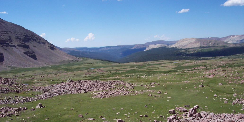
The view from Anderson Pass is astounding, as it is. I remembered it well from the first time I’d been there. I could see Painter Basin, where I’d come from, to the east, and the Yellowstone Drainage, where I was going, to the south. Well, once I felt refreshed, I put my pack back on, and headed down.
It was much steeper going down. I’m glad that I was going down that way, and not up. It was slow going, too. The ground was rocky, and I wanted to make sure that I didn’t slip and sprain my ankle. My plan that day was to make it through three passes, and I was already done with one of them. I knew three passes would be tough for one day, but they were bunched so close together, that if I wanted to make some serious progress, I’d have to do all three.
The next pass was Tungsten Pass, and based off the topography of my map, it didn’t look hard at all, and I didn’t expect much of a challenge there. After that, however, was Porcupine Pass, and I anticipated that that would be quite a bit more challenging.
As I was saying, it was slow going down Anderson Pass, but once I reach the base, I was moving fast. Faster than I’d been going at any other time of the journey. The ground was flat, and the region was grassy. The trail was well defined too. It would be well defined for the rest of the day. I didn’t use my GPS at all that day. I knew I was moving fast, and it felt good. Hell, I was moving so fast, that I kept thinking to myself, I’m going to take a day of rest tomorrow. Just camp out by a lake, and not do anything at all.
I eventually made it to a crossroads. There is a trail that runs through Yellowstone Drainage, along Yellowstone Creek. As I came upon the junction, two horsemen, with a couple of dogs were riding north along that trail. It was my first sighting of human life, and boy was I relieved. It brought great pleasure to me, to know that I wasn’t alone out there. I slowed down my pace so that I could say hello to them as we crossed paths. All I said was, “Hi guys, how’s it going?” They said they were doing just fine, and that was my brief meeting with some other souls.
Admittedly, I would have liked to have had an entire conversation, but these guys were off doing there own thing. Still, just seeing them made me feel much better. Surprisingly, a few minutes later, as I continued along the Highline Trail, I bumped into a couple that was going the other way. My conversation with them wasn’t much more satisfying than the one I’d had with the horsemen, but still, knowing that someone else was out there on foot, made me feel even better. Honestly, I wanted to tell them how miserable I’d been the day before, but that day was going so much better, that all I could them, was that I was doing great. They said they were “enjoying [their] vacation” as well.
Tungsten Pass came shortly after that, and, as my map had indicated, it wasn’t very difficult going over. I stopped at the top of it anyway. If you can even call it a top. It’s more like a hill than a pass. Well, as I said, I stopped at the top, to take a breather, and eat some lunch. Lunch was, of course, Clif Bars and cereal bars. I had wanted to take a break for a full hour, it was only about 1:00 or 2:00 PM, and Porcupine Pass wasn’t much further. But the bugs were annoying me so much, that I figured half an hour was enough. So I moved on.
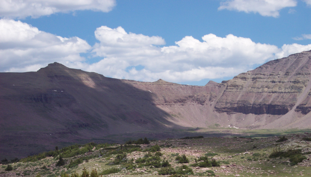
I could see Garfield Basin below me. At that altitude the trees were spread far and wide between, so I could see all the major landmarks, including the lakes and rivers on my map, and Porcupine Pass in the distance, beckoning me to continue. Once again I bumped into some more backpackers. Down in the basin. Two old guys, both with gray hair. Upon meeting them I finally had a conversation with someone. Let me tell you, I let lose, too. I told them how bad the day before had been, how rocky the ground had been, how I couldn’t find the trail, and how today had been so much easier. They asked where I’d come from, and, like many, they didn’t know where Chepeta Lake was, I settled on explaining, “The far east side of the range”.
They’d come from East Fork – Black Forks, a name I recognized as being to the north, and when I checked my map that night, it was pretty much where I thought it was. They’d been out for three days like me. They’d gone over Anderson Pass the day before, and their progress was much slower than mine. I told them I was going about twelve to fifteen miles a day, they laughed about how I was zipping along. They asked if I was going over Porcupine Pass that afternoon, I said that I was. I asked if they were doing the same, they said they planned on staying in the basin, and maybe going over it the next day.
Based on what they told me, their total journey was about half as long as mine. They’d be going over three passes, whereas I was going over seven. Well, after five minutes of talking to them, I was ready to go on. I’d just had a half hour break and I wanted to keep moving, so we said our farewells. Progress was fast through Garfield Basin as it was through Yellowstone, and every minute Porcupine Pass was getting closer and closer. It didn’t look that daunting either. I knew I’d make it over, easy. It wasn’t even comparable to Anderson Pass, and I had previously thought to myself that if I had had to do another “Anderson” Pass that day, I’d have been able to make it.
As I made my approach to the pass, I kept looking back, to see how the two old guys were doing, and honestly, I don’t think they were doing that well. They looked almost like they were on the edge of misery when I had talked to them, and I was really wondering how they were holding up. As I looked back, it appeared that one of them was laying on the ground, almost as if he’d fainted. I wasn’t sure, though, so I kept moving. I figured if they needed help I’d hear shouting, or an emergency whistle, or something. I did keep looking back, to see what they were doing, and to be perfectly honest, I might not have even been looking at them, I may have just been looking at a rock that looked like one guy standing, and one guy laying down.
Porcupine Pass was not difficult going up, but I was moving slow, waddling, you could say. I stopped every few seconds, just to take a few breaths, and a sip of water. Then I’d go a little more. When I made it to the top, the weather was starting to look like rain, so I wanted to get down before any lightning started striking. It was rough going down, not because the ground was rocky, but because the trail was so thin. I mean really thin, it would have been so easy to slip on some loose rocks, and tumble down the slope. I realized, then, that wild animals were not my worst fear out there, but that slipping on some rocks and getting a serious injury was. One slip could have easily led to a bad head injury, or a sprain, either of which could strand someone under the burning sun.
I moved slow, using my hands whenever I was going over the more dangerous parts. It seemed so dangerous, going down that pass, that I wondered how the others would be. If they would be as steep, with such loose rocks. I made it safely to the base, however. No injuries sustained. My feet were hurting, however, and while I had one blister from the day before, I knew that I then had two, one on each foot.
On the west side of Porcupine Pass is the Lake Fork Drainage. It was fast moving once again. I found that marching along side the trail was much easier than walking along the trail itself, the grass was much softer on my blistered feet. The trail was easy to follow, and where there was no trail the rock cairns were visible for great distances. Like I said, though, a storm was coming on, and I was hoping to make it to the treeline before it came.
This was a popular area for livestock as well, and I bumped into quite a few sheep. I even saw some horses a ways off of the trail, which suggested that maybe some horsemen were relaxing nearby. My hope had been to make it to a place called Lambert Lake, but my goal had been to make it to the “other side” of my map. That is, the west side of the range is on one side of my map, and the east side of the range is on the other. I wanted to make it to the west side, and at that time, I had. Lambert Lake was quite a bit further, and as the day grew late, I knew I wouldn’t make it that far.
I literally walked until I couldn’t walk any further. It was around 7:00 PM when I realized I had to camp. The trail wasn’t very well defined either, so I just dropped my gear, found a shroud of trees with a fire pit already built, and looked to make sure water was nearby. It was , but it wasn’t spring water, it was basically muddy water. I figured it would have to do, though. So I set up camp, and started purifying water. I even made dinner, ramen noodles, with powdered eggs mixed in. It really wasn’t that bad. I actually dropped it on the ground, well not exactly on the ground. It fell on top of my cooking pot’s lid. I figured I was already cooking with dirty water anyway, so I ate it without too much complaint.
After that I lay in my tent. I thought I heard some voices go by that evening, which made me wonder if I had camped right on the trail itself. I didn’t really think I had, but I knew the trail was somewhere in the immediate vicinity. The night sky grew darker, and I wanted nothing more than to rest for the night. It was around 8:00 PM when I retired. Not nearly as late as the other days. Better for getting an early start. I took my water bladder into my tent with me. I thought the hot water inside it could help me to warm my cold feet. And it turned out, that the water bladder kept me quite warm throughout the night. Not that I didn’t have my sleeping bag, but it was nice have that bladder for a little extra warmth. My feet were really hurting though, I suppose because I’d covered so much ground. I figured I’d take a look at my blisters in the morning, I didn’t want to deal with them at that moment. All I wanted to do was sleep.
I did look at my map before going to bed, and marveled at how far I’d come. I check my GPS too. My departure vehicle was only sixteen miles away. I had more than sixteen miles to go, sure, but the last time I had checked to see how far the vehicle was, it was over thirty miles. I’d come so far, and really felt like I’d made some serious progress.
The journey continues on Day 4.